Žitenice
Žitenice | |
|---|---|
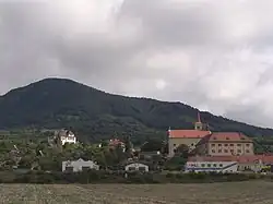 Church and castle in Žitěnice | |
 Flag  Coat of arms | |
 Žitenice Location in the Czech Republic | |
| Coordinates: 50°33′19″N 14°9′24″E / 50.55528°N 14.15667°E | |
| Country | |
| Region | Ústí nad Labem |
| District | Litoměřice |
| First mentioned | 1057 |
| Area | |
• Total | 13.08 km2 (5.05 sq mi) |
| Elevation | 224 m (735 ft) |
| Population (2025-01-01)[1] | |
• Total | 1,643 |
| • Density | 130/km2 (330/sq mi) |
| Time zone | UTC+1 (CET) |
| • Summer (DST) | UTC+2 (CEST) |
| Postal code | 411 41 |
| Website | www |
Žitenice (German: Schüttenitz) is a municipality and village in Litoměřice District in the Ústí nad Labem Region of the Czech Republic. It has about 1,600 inhabitants.
Žitenice lies approximately 4 kilometres (2 mi) north-east of Litoměřice, 15 km (9 mi) south-east of Ústí nad Labem, and 56 km (35 mi) north of Prague.
Administrative division
Žitenice consists of three municipal parts (in brackets population according to the 2021 census):[2]
- Žitenice (838)
- Pohořany (476)
- Skalice (293)
Demographics
| Year | Pop. | ±% |
|---|---|---|
| 1869 | 1,715 | — |
| 1880 | 1,857 | +8.3% |
| 1890 | 1,841 | −0.9% |
| 1900 | 1,953 | +6.1% |
| 1910 | 2,135 | +9.3% |
| 1921 | 1,897 | −11.1% |
| 1930 | 1,985 | +4.6% |
| 1950 | 1,307 | −34.2% |
| 1961 | 1,491 | +14.1% |
| 1970 | 1,496 | +0.3% |
| 1980 | 1,358 | −9.2% |
| 1991 | 1,171 | −13.8% |
| 2001 | 1,304 | +11.4% |
| 2011 | 1,500 | +15.0% |
| 2021 | 1,607 | +7.1% |
| Source: Censuses[3][4] | ||
References
- ^ "Population of Municipalities – 1 January 2025". Czech Statistical Office. 2025-05-16.
- ^ "Public Census 2021 – basic data". Public Database (in Czech). Czech Statistical Office. 2022.
- ^ "Historický lexikon obcí České republiky 1869–2011" (in Czech). Czech Statistical Office. 2015-12-21.
- ^ "Population Census 2021: Population by sex". Public Database. Czech Statistical Office. 2021-03-27.
External links
Wikimedia Commons has media related to Žitenice.