Třebušín
Třebušín | |
|---|---|
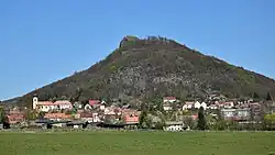 The village of Třebušín under Kalich Hill | |
 Flag  Coat of arms | |
 Třebušín Location in the Czech Republic | |
| Coordinates: 50°35′59″N 14°12′20″E / 50.59972°N 14.20556°E | |
| Country | |
| Region | Ústí nad Labem |
| District | Litoměřice |
| First mentioned | 1169 |
| Area | |
• Total | 15.62 km2 (6.03 sq mi) |
| Elevation | 423 m (1,388 ft) |
| Population (2025-01-01)[1] | |
• Total | 606 |
| • Density | 39/km2 (100/sq mi) |
| Time zone | UTC+1 (CET) |
| • Summer (DST) | UTC+2 (CEST) |
| Postal code | 412 01 |
| Website | www |
Třebušín is a municipality and village in Litoměřice District in the Ústí nad Labem Region of the Czech Republic. It has about 600 inhabitants.
Třebušín lies approximately 10 kilometres (6 mi) north-east of Litoměřice, 14 km (9 mi) south-east of Ústí nad Labem, and 59 km (37 mi) north of Prague.
Administrative division
Třebušín consists of five municipal parts (in brackets population according to the 2021 census):[2]
- Třebušín (372)
- Dolní Týnec (57)
- Horní Týnec (48)
- Kotelice (36)
- Řepčice (77)
Demographics
| Year | Pop. | ±% |
|---|---|---|
| 1869 | 1,516 | — |
| 1880 | 1,391 | −8.2% |
| 1890 | 1,498 | +7.7% |
| 1900 | 1,383 | −7.7% |
| 1910 | 1,356 | −2.0% |
| 1921 | 1,301 | −4.1% |
| 1930 | 1,347 | +3.5% |
| 1950 | 637 | −52.7% |
| 1961 | 657 | +3.1% |
| 1970 | 518 | −21.2% |
| 1980 | 505 | −2.5% |
| 1991 | 418 | −17.2% |
| 2001 | 451 | +7.9% |
| 2011 | 545 | +20.8% |
| 2021 | 590 | +8.3% |
| Source: Censuses[3][4] | ||
References
- ^ "Population of Municipalities – 1 January 2025". Czech Statistical Office. 2025-05-16.
- ^ "Public Census 2021 – basic data". Public Database (in Czech). Czech Statistical Office. 2022.
- ^ "Historický lexikon obcí České republiky 1869–2011" (in Czech). Czech Statistical Office. 2015-12-21.
- ^ "Population Census 2021: Population by sex". Public Database. Czech Statistical Office. 2021-03-27.
External links
Wikimedia Commons has media related to Třebušín.