Siřejovice
Siřejovice | |
|---|---|
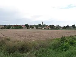 View from the west | |
 Flag  Coat of arms | |
 Siřejovice Location in the Czech Republic | |
| Coordinates: 50°28′42″N 14°4′16″E / 50.47833°N 14.07111°E | |
| Country | |
| Region | Ústí nad Labem |
| District | Litoměřice |
| First mentioned | 1227 |
| Area | |
• Total | 6.16 km2 (2.38 sq mi) |
| Elevation | 185 m (607 ft) |
| Population (2025-01-01)[1] | |
• Total | 269 |
| • Density | 44/km2 (110/sq mi) |
| Time zone | UTC+1 (CET) |
| • Summer (DST) | UTC+2 (CEST) |
| Postal code | 410 02 |
| Website | www |
Siřejovice is a municipality and village in Litoměřice District in the Ústí nad Labem Region of the Czech Republic. It has about 300 inhabitants.
Siřejovice lies approximately 7 kilometres (4 mi) south-west of Litoměřice, 21 km (13 mi) south of Ústí nad Labem, and 50 km (31 mi) north-west of Prague.
Demographics
| Year | Pop. | ±% |
|---|---|---|
| 1869 | 363 | — |
| 1880 | 376 | +3.6% |
| 1890 | 345 | −8.2% |
| 1900 | 373 | +8.1% |
| 1910 | 422 | +13.1% |
| 1921 | 413 | −2.1% |
| 1930 | 515 | +24.7% |
| 1950 | 356 | −30.9% |
| 1961 | 332 | −6.7% |
| 1970 | 318 | −4.2% |
| 1980 | 280 | −11.9% |
| 1991 | 252 | −10.0% |
| 2001 | 276 | +9.5% |
| 2011 | 267 | −3.3% |
| 2021 | 260 | −2.6% |
| Source: Censuses[2][3] | ||
References
- ^ "Population of Municipalities – 1 January 2025". Czech Statistical Office. 2025-05-16.
- ^ "Historický lexikon obcí České republiky 1869–2011" (in Czech). Czech Statistical Office. 2015-12-21.
- ^ "Population Census 2021: Population by sex". Public Database. Czech Statistical Office. 2021-03-27.
External links
Wikimedia Commons has media related to Siřejovice.