Libotenice
Libotenice | |
|---|---|
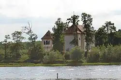 Church of Saint Catherine | |
 Flag  Coat of arms | |
 Libotenice Location in the Czech Republic | |
| Coordinates: 50°28′37″N 14°13′46″E / 50.47694°N 14.22944°E | |
| Country | |
| Region | Ústí nad Labem |
| District | Litoměřice |
| First mentioned | 1226 |
| Area | |
• Total | 5.72 km2 (2.21 sq mi) |
| Elevation | 151 m (495 ft) |
| Population (2025-01-01)[1] | |
• Total | 444 |
| • Density | 78/km2 (200/sq mi) |
| Time zone | UTC+1 (CET) |
| • Summer (DST) | UTC+2 (CEST) |
| Postal code | 412 01 |
| Website | www |
Libotenice is a municipality and village in Litoměřice District in the Ústí nad Labem Region of the Czech Republic. It has about 400 inhabitants.
Libotenice lies approximately 10 kilometres (6 mi) south-east of Litoměřice, 24 km (15 mi) south-east of Ústí nad Labem, and 46 km (29 mi) north of Prague.
Demographics
| Year | Pop. | ±% |
|---|---|---|
| 1869 | 358 | — |
| 1880 | 374 | +4.5% |
| 1890 | 407 | +8.8% |
| 1900 | 467 | +14.7% |
| 1910 | 543 | +16.3% |
| 1921 | 504 | −7.2% |
| 1930 | 513 | +1.8% |
| 1950 | 381 | −25.7% |
| 1961 | 403 | +5.8% |
| 1970 | 381 | −5.5% |
| 1980 | 364 | −4.5% |
| 1991 | 408 | +12.1% |
| 2001 | 400 | −2.0% |
| 2011 | 441 | +10.3% |
| 2021 | 426 | −3.4% |
| Source: Censuses[2][3] | ||
References
- ^ "Population of Municipalities – 1 January 2025". Czech Statistical Office. 2025-05-16.
- ^ "Historický lexikon obcí České republiky 1869–2011" (in Czech). Czech Statistical Office. 2015-12-21.
- ^ "Population Census 2021: Population by sex". Public Database. Czech Statistical Office. 2021-03-27.
External links
Wikimedia Commons has media related to Libotenice.