Darnets
Darnets | |
|---|---|
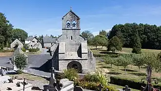 The church of Saint-Maurice, in Darnets | |
.svg.png) Coat of arms | |
Location of Darnets | |
 Darnets  Darnets | |
| Coordinates: 45°25′37″N 2°06′42″E / 45.4269°N 2.1117°E | |
| Country | France |
| Region | Nouvelle-Aquitaine |
| Department | Corrèze |
| Arrondissement | Ussel |
| Canton | Plateau de Millevaches |
| Government | |
| • Mayor (2020–2026) | Philippe Rossignol[1] |
Area 1 | 25.42 km2 (9.81 sq mi) |
| Population (2022)[2] | 309 |
| • Density | 12/km2 (31/sq mi) |
| Time zone | UTC+01:00 (CET) |
| • Summer (DST) | UTC+02:00 (CEST) |
| INSEE/Postal code | 19070 /19300 |
| Elevation | 471–663 m (1,545–2,175 ft) |
| 1 French Land Register data, which excludes lakes, ponds, glaciers > 1 km2 (0.386 sq mi or 247 acres) and river estuaries. | |
Darnets (French pronunciation: [daʁnɛ]) is a commune in the Corrèze department in central France.
Geography
The Luzège forms the commune's eastern border.
Population
| Year | Pop. | ±% |
|---|---|---|
| 1962 | 275 | — |
| 1968 | 283 | +2.9% |
| 1975 | 279 | −1.4% |
| 1982 | 321 | +15.1% |
| 1990 | 304 | −5.3% |
| 1999 | 341 | +12.2% |
| 2008 | 344 | +0.9% |
See also
References
- ^ "Répertoire national des élus: les maires" (in French). data.gouv.fr, Plateforme ouverte des données publiques françaises. 13 September 2022.
- ^ "Populations de référence 2022" (in French). The National Institute of Statistics and Economic Studies. 19 December 2024.
Wikimedia Commons has media related to Darnets.