Servières-le-Château
Servières-le-Château
Serviera dau Chasteu (Occitan) | |
|---|---|
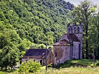 The Chapel of Glény | |
 Coat of arms | |
Location of Servières-le-Château | |
 Servières-le-Château  Servières-le-Château | |
| Coordinates: 45°07′52″N 2°01′33″E / 45.1311°N 2.0258°E | |
| Country | France |
| Region | Nouvelle-Aquitaine |
| Department | Corrèze |
| Arrondissement | Tulle |
| Canton | Argentat-sur-Dordogne |
| Government | |
| • Mayor (2020–2026) | Hervé Clavière[1] |
Area 1 | 24.24 km2 (9.36 sq mi) |
| Population (2022)[2] | 568 |
| • Density | 23/km2 (61/sq mi) |
| Time zone | UTC+01:00 (CET) |
| • Summer (DST) | UTC+02:00 (CEST) |
| INSEE/Postal code | 19258 /19220 |
| Elevation | 195–589 m (640–1,932 ft) (avg. 480 m or 1,570 ft) |
| 1 French Land Register data, which excludes lakes, ponds, glaciers > 1 km2 (0.386 sq mi or 247 acres) and river estuaries. | |
Servières-le-Château (French: [sɛʁvjɛʁ lə ʃɑto]; Occitan: Serviera dau Chasteu) is a commune in the Corrèze department in central France.
Population
| Year | Pop. | ±% |
|---|---|---|
| 1962 | 587 | — |
| 1968 | 645 | +9.9% |
| 1975 | 618 | −4.2% |
| 1982 | 718 | +16.2% |
| 1990 | 772 | +7.5% |
| 1999 | 719 | −6.9% |
| 2008 | 673 | −6.4% |
See also
References
- ^ "Répertoire national des élus: les maires" (in French). data.gouv.fr, Plateforme ouverte des données publiques françaises. 13 September 2022.
- ^ "Populations de référence 2022" (in French). The National Institute of Statistics and Economic Studies. 19 December 2024.
Wikimedia Commons has media related to Servières-le-Château.