Jaroměřice
Jaroměřice | |
|---|---|
 Church of All Saints | |
 Flag  Coat of arms | |
 Jaroměřice Location in the Czech Republic | |
| Coordinates: 49°37′32″N 16°45′7″E / 49.62556°N 16.75194°E | |
| Country | |
| Region | Pardubice |
| District | Svitavy |
| Founded | 1080s |
| Area | |
• Total | 22.06 km2 (8.52 sq mi) |
| Elevation | 368 m (1,207 ft) |
| Population (2025-01-01)[1] | |
• Total | 1,182 |
| • Density | 54/km2 (140/sq mi) |
| Time zone | UTC+1 (CET) |
| • Summer (DST) | UTC+2 (CEST) |
| Postal codes | 569 43, 569 44 |
| Website | www |
Jaroměřice is a municipality and village in Svitavy District in the Pardubice Region of the Czech Republic. It has about 1,200 inhabitants.
Jaroměřice lies approximately 26 kilometres (16 mi) south-east of Svitavy, 85 km (53 mi) south-east of Pardubice, and 176 km (109 mi) east of Prague.
Administrative division
Jaroměřice consists of two municipal parts (in brackets population according to the 2021 census):[2]
- Jaroměřice (1,113)
- Nový Dvůr (44)
Demographics
| Year | Pop. | ±% |
|---|---|---|
| 1869 | 1,911 | — |
| 1880 | 1,875 | −1.9% |
| 1890 | 1,851 | −1.3% |
| 1900 | 1,944 | +5.0% |
| 1910 | 2,026 | +4.2% |
| 1921 | 1,974 | −2.6% |
| 1930 | 1,955 | −1.0% |
| 1950 | 1,472 | −24.7% |
| 1961 | 1,568 | +6.5% |
| 1970 | 1,418 | −9.6% |
| 1980 | 1,316 | −7.2% |
| 1991 | 1,311 | −0.4% |
| 2001 | 1,267 | −3.4% |
| 2011 | 1,197 | −5.5% |
| 2021 | 1,157 | −3.3% |
| Source: Censuses[3][4] | ||
Gallery
-
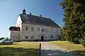 Jaroměřice Castle
 -
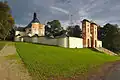 Church of the Exaltation of the Holy Cross on the Calvary
References
- ^ "Population of Municipalities – 1 January 2025". Czech Statistical Office. 2025-05-16.
- ^ "Public Census 2021 – basic data". Public Database (in Czech). Czech Statistical Office. 2022.
- ^ "Historický lexikon obcí České republiky 1869–2011" (in Czech). Czech Statistical Office. 2015-12-21.
- ^ "Population Census 2021: Population by sex". Public Database. Czech Statistical Office. 2021-03-27.
External links
Wikimedia Commons has media related to Jaroměřice.