Rychnov na Moravě
Rychnov na Moravě | |
|---|---|
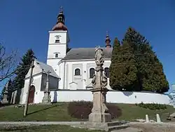 Church of Saint Nicholas | |
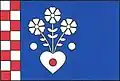 Flag 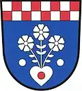 Coat of arms | |
 Rychnov na Moravě Location in the Czech Republic | |
| Coordinates: 49°49′45″N 16°38′25″E / 49.82917°N 16.64028°E | |
| Country | |
| Region | Pardubice |
| District | Svitavy |
| First mentioned | 1365 |
| Area | |
• Total | 23.58 km2 (9.10 sq mi) |
| Elevation | 355 m (1,165 ft) |
| Population (2025-01-01)[1] | |
• Total | 607 |
| • Density | 26/km2 (67/sq mi) |
| Time zone | UTC+1 (CET) |
| • Summer (DST) | UTC+2 (CEST) |
| Postal code | 569 34 |
| Website | www |
Rychnov na Moravě (German: Reichenau) is a municipality and village in Svitavy District in the Pardubice Region of the Czech Republic. It has about 600 inhabitants.
Rychnov na Moravě lies approximately 15 kilometres (9 mi) north-east of Svitavy, 66 km (41 mi) east of Pardubice, and 161 km (100 mi) east of Prague.
Demographics
| Year | Pop. | ±% |
|---|---|---|
| 1869 | 1,645 | — |
| 1880 | 1,754 | +6.6% |
| 1890 | 1,712 | −2.4% |
| 1900 | 1,582 | −7.6% |
| 1910 | 1,457 | −7.9% |
| 1921 | 1,446 | −0.8% |
| 1930 | 1,402 | −3.0% |
| 1950 | 785 | −44.0% |
| 1961 | 852 | +8.5% |
| 1970 | 762 | −10.6% |
| 1980 | 736 | −3.4% |
| 1991 | 601 | −18.3% |
| 2001 | 595 | −1.0% |
| 2011 | 567 | −4.7% |
| 2021 | 600 | +5.8% |
| Source: Censuses[2][3] | ||
References
- ^ "Population of Municipalities – 1 January 2025". Czech Statistical Office. 2025-05-16.
- ^ "Historický lexikon obcí České republiky 1869–2011" (in Czech). Czech Statistical Office. 2015-12-21.
- ^ "Population Census 2021: Population by sex". Public Database. Czech Statistical Office. 2021-03-27.
External links
Wikimedia Commons has media related to Rychnov na Moravě.