Příluka
Příluka | |
|---|---|
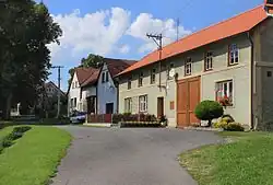 Upper part of Příluka | |
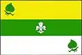 Flag  Coat of arms | |
 Příluka Location in the Czech Republic | |
| Coordinates: 49°51′54″N 16°9′24″E / 49.86500°N 16.15667°E | |
| Country | |
| Region | Pardubice |
| District | Svitavy |
| First mentioned | 1355 |
| Area | |
• Total | 3.81 km2 (1.47 sq mi) |
| Elevation | 455 m (1,493 ft) |
| Population (2025-01-01)[1] | |
• Total | 169 |
| • Density | 44/km2 (110/sq mi) |
| Time zone | UTC+1 (CET) |
| • Summer (DST) | UTC+2 (CEST) |
| Postal code | 539 44 |
| Website | www |
Příluka is a municipality and village in Svitavy District in the Pardubice Region of the Czech Republic. It has about 200 inhabitants.
Příluka lies approximately 26 kilometres (16 mi) north-west of Svitavy, 34 km (21 mi) south-east of Pardubice, and 127 km (79 mi) east of Prague.
Demographics
| Year | Pop. | ±% |
|---|---|---|
| 1869 | 340 | — |
| 1880 | 354 | +4.1% |
| 1890 | 323 | −8.8% |
| 1900 | 319 | −1.2% |
| 1910 | 346 | +8.5% |
| 1921 | 332 | −4.0% |
| 1930 | 320 | −3.6% |
| 1950 | 224 | −30.0% |
| 1961 | 223 | −0.4% |
| 1970 | 207 | −7.2% |
| 1980 | 195 | −5.8% |
| 1991 | 176 | −9.7% |
| 2001 | 162 | −8.0% |
| 2011 | 179 | +10.5% |
| 2021 | 158 | −11.7% |
| Source: Censuses[2][3] | ||
References
- ^ "Population of Municipalities – 1 January 2025". Czech Statistical Office. 2025-05-16.
- ^ "Historický lexikon obcí České republiky 1869–2011" (in Czech). Czech Statistical Office. 2015-12-21.
- ^ "Population Census 2021: Population by sex". Public Database. Czech Statistical Office. 2021-03-27.
External links
Wikimedia Commons has media related to Příluka.