La Heunière
La Heunière | |
|---|---|
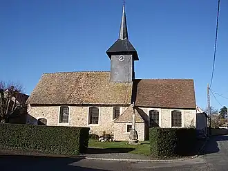 The church of Saint-Jean-Baptiste in La Heunière | |
.svg.png) Coat of arms | |
Location of La Heunière | |
 La Heunière  La Heunière | |
| Coordinates: 49°03′44″N 1°24′54″E / 49.0622°N 1.415°E | |
| Country | France |
| Region | Normandy |
| Department | Eure |
| Arrondissement | Les Andelys |
| Canton | Pacy-sur-Eure |
| Intercommunality | Seine Normandie Agglomération |
| Government | |
| • Mayor (2020–2026) | Jérôme Foucher[1] |
Area 1 | 3.07 km2 (1.19 sq mi) |
| Population (2022)[2] | 454 |
| • Density | 150/km2 (380/sq mi) |
| Time zone | UTC+01:00 (CET) |
| • Summer (DST) | UTC+02:00 (CEST) |
| INSEE/Postal code | 27336 /27950 |
| Elevation | 122–143 m (400–469 ft) (avg. 142 m or 466 ft) |
| 1 French Land Register data, which excludes lakes, ponds, glaciers > 1 km2 (0.386 sq mi or 247 acres) and river estuaries. | |
La Heunière (French pronunciation: [la œnjɛʁ]) is a commune in the Eure department in northern France.
Population
| Year | Pop. | ±% |
|---|---|---|
| 1962 | 110 | — |
| 1968 | 126 | +14.5% |
| 1975 | 135 | +7.1% |
| 1982 | 195 | +44.4% |
| 1990 | 234 | +20.0% |
| 1999 | 241 | +3.0% |
| 2008 | 253 | +5.0% |
See also
References
- ^ "Répertoire national des élus: les maires". data.gouv.fr, Plateforme ouverte des données publiques françaises (in French). 9 August 2021.
- ^ "Populations de référence 2022" (in French). The National Institute of Statistics and Economic Studies. 19 December 2024.
Wikimedia Commons has media related to La Heunière.