Longueville, Calvados
Longueville | |
|---|---|
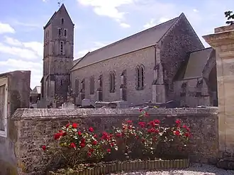 The church in Longueville | |
Location of Longueville | |
 Longueville  Longueville | |
| Coordinates: 49°20′27″N 0°57′31″W / 49.3408°N 0.9586°W | |
| Country | France |
| Region | Normandy |
| Department | Calvados |
| Arrondissement | Bayeux |
| Canton | Trévières |
| Intercommunality | CC Isigny-Omaha Intercom |
| Government | |
| • Mayor (2020–2026) | Daniel Joret[1] |
Area 1 | 6.54 km2 (2.53 sq mi) |
| Population (2022)[2] | 286 |
| • Density | 44/km2 (110/sq mi) |
| Time zone | UTC+01:00 (CET) |
| • Summer (DST) | UTC+02:00 (CEST) |
| INSEE/Postal code | 14378 /14230 |
| Elevation | 0–50 m (0–164 ft) |
| 1 French Land Register data, which excludes lakes, ponds, glaciers > 1 km2 (0.386 sq mi or 247 acres) and river estuaries. | |
Longueville (French pronunciation: [lɔ̃ɡvil] ⓘ) is a commune in the Calvados department in the Normandy region in northwestern France.
Population
| Year | Pop. | ±% |
|---|---|---|
| 1962 | 370 | — |
| 1968 | 308 | −16.8% |
| 1975 | 272 | −11.7% |
| 1982 | 251 | −7.7% |
| 1990 | 239 | −4.8% |
| 1999 | 237 | −0.8% |
| 2008 | 256 | +8.0% |
See also
References
- ^ "Répertoire national des élus: les maires". data.gouv.fr, Plateforme ouverte des données publiques françaises (in French). 9 August 2021.
- ^ "Populations de référence 2022" (in French). The National Institute of Statistics and Economic Studies. 19 December 2024.
Wikimedia Commons has media related to Longueville (Calvados).