Saint-Sylvain, Calvados
Saint-Sylvain | |
|---|---|
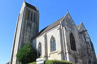 The church in Saint-Sylvain | |
 Coat of arms | |
Location of Saint-Sylvain | |
 Saint-Sylvain  Saint-Sylvain | |
| Coordinates: 49°03′25″N 0°12′57″W / 49.0569°N 0.2158°W | |
| Country | France |
| Region | Normandy |
| Department | Calvados |
| Arrondissement | Caen |
| Canton | Le Hom |
| Intercommunality | CC Val ès Dunes |
| Government | |
| • Mayor (2020–2026) | Régis Croteau[1] |
Area 1 | 13.48 km2 (5.20 sq mi) |
| Population (2022)[2] | 1,454 |
| • Density | 110/km2 (280/sq mi) |
| Time zone | UTC+01:00 (CET) |
| • Summer (DST) | UTC+02:00 (CEST) |
| INSEE/Postal code | 14659 /14190 |
| Elevation | 38–86 m (125–282 ft) (avg. 38 m or 125 ft) |
| 1 French Land Register data, which excludes lakes, ponds, glaciers > 1 km2 (0.386 sq mi or 247 acres) and river estuaries. | |
Saint-Sylvain (French pronunciation: [sɛ̃ silvɛ̃] ⓘ) is a commune in the Calvados department in the Normandy region in northwestern France.
Population
| Year | Pop. | ±% |
|---|---|---|
| 1962 | 642 | — |
| 1968 | 642 | +0.0% |
| 1975 | 715 | +11.4% |
| 1982 | 838 | +17.2% |
| 1990 | 850 | +1.4% |
| 1999 | 977 | +14.9% |
| 2008 | 1,198 | +22.6% |
See also
References
- ^ "Répertoire national des élus: les maires". data.gouv.fr, Plateforme ouverte des données publiques françaises (in French). 2 December 2020.
- ^ "Populations de référence 2022" (in French). The National Institute of Statistics and Economic Studies. 19 December 2024.
Wikimedia Commons has media related to Saint-Sylvain (Calvados).