Mostkovice
Mostkovice | |
|---|---|
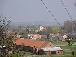 View towards Mostkovice | |
 Flag  Coat of arms | |
 Mostkovice Location in the Czech Republic | |
| Coordinates: 49°28′20″N 17°3′8″E / 49.47222°N 17.05222°E | |
| Country | |
| Region | Olomouc |
| District | Prostějov |
| First mentioned | 1141 |
| Area | |
• Total | 8.34 km2 (3.22 sq mi) |
| Elevation | 253 m (830 ft) |
| Population (2025-01-01)[1] | |
• Total | 1,646 |
| • Density | 200/km2 (510/sq mi) |
| Time zone | UTC+1 (CET) |
| • Summer (DST) | UTC+2 (CEST) |
| Postal code | 798 02 |
| Website | www |
Mostkovice is a municipality and village in Prostějov District in the Olomouc Region of the Czech Republic. It has about 1,600 inhabitants.
Mostkovice lies approximately 5 kilometres (3 mi) west of Prostějov, 21 km (13 mi) south-west of Olomouc, and 201 km (125 mi) east of Prague.
Demographics
| Year | Pop. | ±% |
|---|---|---|
| 1869 | 885 | — |
| 1880 | 972 | +9.8% |
| 1890 | 1,055 | +8.5% |
| 1900 | 1,168 | +10.7% |
| 1910 | 1,290 | +10.4% |
| 1921 | 1,351 | +4.7% |
| 1930 | 1,448 | +7.2% |
| 1950 | 1,724 | +19.1% |
| 1961 | 1,511 | −12.4% |
| 1970 | 1,413 | −6.5% |
| 1980 | 1,415 | +0.1% |
| 1991 | 1,315 | −7.1% |
| 2001 | 1,294 | −1.6% |
| 2011 | 1,497 | +15.7% |
| 2021 | 1,571 | +4.9% |
| Source: Censuses[2][3] | ||
References
- ^ "Population of Municipalities – 1 January 2025". Czech Statistical Office. 2025-05-16.
- ^ "Historický lexikon obcí České republiky 1869–2011" (in Czech). Czech Statistical Office. 2015-12-21.
- ^ "Population Census 2021: Population by sex". Public Database. Czech Statistical Office. 2021-03-27.
External links
Wikimedia Commons has media related to Mostkovice.