Zdětín (Prostějov District)
Zdětín | |
|---|---|
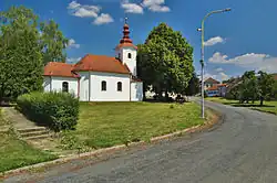 Chapel of Saint Anne | |
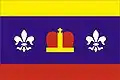 Flag  Coat of arms | |
 Zdětín Location in the Czech Republic | |
| Coordinates: 49°30′21″N 16°59′20″E / 49.50583°N 16.98889°E | |
| Country | |
| Region | Olomouc |
| District | Prostějov |
| First mentioned | 1368 |
| Area | |
• Total | 5.33 km2 (2.06 sq mi) |
| Elevation | 341 m (1,119 ft) |
| Population (2025-01-01)[1] | |
• Total | 390 |
| • Density | 73/km2 (190/sq mi) |
| Time zone | UTC+1 (CET) |
| • Summer (DST) | UTC+2 (CEST) |
| Postal code | 798 43 |
| Website | www |
Zdětín is a municipality and village in Prostějov District in the Olomouc Region of the Czech Republic. It has about 400 inhabitants.
Zdětín lies approximately 10 kilometres (6 mi) north-west of Prostějov, 22 km (14 mi) south-west of Olomouc, and 196 km (122 mi) east of Prague.
History
The first written mention of Zdětín is from 1368. A school was built in 1876.[2]
Demographics
| Year | Pop. | ±% |
|---|---|---|
| 1869 | 478 | — |
| 1880 | 532 | +11.3% |
| 1890 | 501 | −5.8% |
| 1900 | 477 | −4.8% |
| 1910 | 502 | +5.2% |
| 1921 | 502 | +0.0% |
| 1930 | 491 | −2.2% |
| 1950 | 440 | −10.4% |
| 1961 | 427 | −3.0% |
| 1970 | 374 | −12.4% |
| 1980 | 320 | −14.4% |
| 1991 | 277 | −13.4% |
| 2001 | 289 | +4.3% |
| 2011 | 293 | +1.4% |
| 2021 | 360 | +22.9% |
| Source: Censuses[3][4] | ||
References
- ^ "Population of Municipalities – 1 January 2025". Czech Statistical Office. 2025-05-16.
- ^ "Obraz o historii a životě obce Zdětín" (in Czech). Obec Zdětín. Retrieved 2022-10-11.
- ^ "Historický lexikon obcí České republiky 1869–2011" (in Czech). Czech Statistical Office. 2015-12-21.
- ^ "Population Census 2021: Population by sex". Public Database. Czech Statistical Office. 2021-03-27.
External links
Wikimedia Commons has media related to Zdětín (Prostějov District).