Chélieu
Chélieu | |
|---|---|
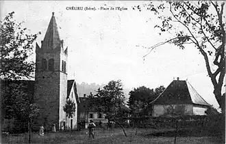 The church at the start of the 20th century | |
Location of Chélieu | |
 Chélieu  Chélieu | |
| Coordinates: 45°30′46″N 5°28′36″E / 45.5128°N 5.4767°E | |
| Country | France |
| Region | Auvergne-Rhône-Alpes |
| Department | Isère |
| Arrondissement | La Tour-du-Pin |
| Canton | Le Grand-Lemps |
| Intercommunality | Les Vals du Dauphiné |
| Government | |
| • Mayor (2020–2026) | Max Gauthier[1] |
Area 1 | 10.13 km2 (3.91 sq mi) |
| Population (2022)[2] | 739 |
| • Density | 73/km2 (190/sq mi) |
| Time zone | UTC+01:00 (CET) |
| • Summer (DST) | UTC+02:00 (CEST) |
| INSEE/Postal code | 38098 /38730 |
| Elevation | 374–607 m (1,227–1,991 ft) |
| 1 French Land Register data, which excludes lakes, ponds, glaciers > 1 km2 (0.386 sq mi or 247 acres) and river estuaries. | |
Chélieu (French pronunciation: [ʃeljø]) is a commune in the Isère department in southeastern France.
Geography
The Bourbre flows northeast through the eastern part of the commune and forms part of its northeastern border.
Population
| Year | Pop. | ±% p.a. |
|---|---|---|
| 1968 | 378 | — |
| 1975 | 323 | −2.22% |
| 1982 | 368 | +1.88% |
| 1990 | 415 | +1.51% |
| 1999 | 522 | +2.58% |
| 2007 | 642 | +2.62% |
| 2012 | 680 | +1.16% |
| 2017 | 676 | −0.12% |
| Source: INSEE[3] | ||
See also
References
- ^ "Répertoire national des élus: les maires" (in French). data.gouv.fr, Plateforme ouverte des données publiques françaises. 13 September 2022.
- ^ "Populations de référence 2022" (in French). The National Institute of Statistics and Economic Studies. 19 December 2024.
- ^ Population en historique depuis 1968, INSEE
Wikimedia Commons has media related to Chélieu.