Mottier
Mottier | |
|---|---|
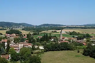 An aerial view of Mottier | |
Location of Mottier | |
 Mottier  Mottier | |
| Coordinates: 45°25′11″N 5°19′04″E / 45.4197°N 5.3178°E | |
| Country | France |
| Region | Auvergne-Rhône-Alpes |
| Department | Isère |
| Arrondissement | Vienne |
| Canton | Bièvre |
| Government | |
| • Mayor (2020–2026) | Isabelle Rivard[1] |
Area 1 | 10.72 km2 (4.14 sq mi) |
| Population (2022)[2] | 843 |
| • Density | 79/km2 (200/sq mi) |
| Time zone | UTC+01:00 (CET) |
| • Summer (DST) | UTC+02:00 (CEST) |
| INSEE/Postal code | 38267 /38260 |
| Elevation | 448–641 m (1,470–2,103 ft) (avg. 480 m or 1,570 ft) |
| 1 French Land Register data, which excludes lakes, ponds, glaciers > 1 km2 (0.386 sq mi or 247 acres) and river estuaries. | |
Mottier (French pronunciation: [mɔtje]) is a French commune located in the Isère department in the Auvergne-Rhône-Alpes region.[3] The village is overlooked by the ruins of an old fortified house dating from the 12th century.
Demography
| Year | Pop. | ±% p.a. |
|---|---|---|
| 1968 | 362 | — |
| 1975 | 357 | −0.20% |
| 1982 | 414 | +2.14% |
| 1990 | 468 | +1.54% |
| 1999 | 511 | +0.98% |
| 2009 | 681 | +2.91% |
| 2014 | 684 | +0.09% |
| 2020 | 790 | +2.43% |
| Source: INSEE[4] | ||
The inhabitants of the commune are called the Mottiérots in French.
See also
References
- ^ "Répertoire national des élus: les maires". data.gouv.fr, Plateforme ouverte des données publiques françaises (in French). 9 August 2021.
- ^ "Populations de référence 2022" (in French). The National Institute of Statistics and Economic Studies. 19 December 2024.
- ^ INSEE commune file
- ^ Population en historique depuis 1968, INSEE
Wikimedia Commons has media related to Mottier.