Denonville
Denonville | |
|---|---|
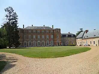 Chateau | |
Location of Denonville | |
 Denonville  Denonville | |
| Coordinates: 48°23′35″N 1°48′44″E / 48.3931°N 1.8122°E | |
| Country | France |
| Region | Centre-Val de Loire |
| Department | Eure-et-Loir |
| Arrondissement | Chartres |
| Canton | Auneau |
| Intercommunality | CA Chartres Métropole |
| Government | |
| • Mayor (2020–2026) | Evelyne Lagoutte[1] |
Area 1 | 12.82 km2 (4.95 sq mi) |
| Population (2022)[2] | 773 |
| • Density | 60/km2 (160/sq mi) |
| Time zone | UTC+01:00 (CET) |
| • Summer (DST) | UTC+02:00 (CEST) |
| INSEE/Postal code | 28129 /28700 |
| Elevation | 142–155 m (466–509 ft) (avg. 148 m or 486 ft) |
| 1 French Land Register data, which excludes lakes, ponds, glaciers > 1 km2 (0.386 sq mi or 247 acres) and river estuaries. | |
Denonville (French pronunciation: [dənɔ̃vil]) is a commune in the Eure-et-Loir department in northern France.
Population
| Year | Pop. | ±% |
|---|---|---|
| 1962 | 340 | — |
| 1968 | 344 | +1.2% |
| 1975 | 349 | +1.5% |
| 1982 | 374 | +7.2% |
| 1990 | 607 | +62.3% |
| 1999 | 672 | +10.7% |
| 2008 | 776 | +15.5% |
See also
References
- ^ "Répertoire national des élus: les maires". data.gouv.fr, Plateforme ouverte des données publiques françaises (in French). 9 August 2021.
- ^ "Populations de référence 2022" (in French). The National Institute of Statistics and Economic Studies. 19 December 2024.
Wikimedia Commons has media related to Denonville.