Gommegnies
Gommegnies | |
|---|---|
_mairie.JPG) The town hall in Gommegnies | |
_actuel.svg.png) Coat of arms | |
Location of Gommegnies | |
 Gommegnies  Gommegnies | |
| Coordinates: 50°16′18″N 3°42′21″E / 50.271596°N 3.705856°E | |
| Country | France |
| Region | Hauts-de-France |
| Department | Nord |
| Arrondissement | Avesnes-sur-Helpe |
| Canton | Aulnoye-Aymeries |
| Intercommunality | CC Pays de Mormal |
| Government | |
| • Mayor (2020–2026) | Benoît Guiost[1] |
Area 1 | 15.78 km2 (6.09 sq mi) |
| Population (2022)[2] | 2,272 |
| • Density | 140/km2 (370/sq mi) |
| Time zone | UTC+01:00 (CET) |
| • Summer (DST) | UTC+02:00 (CEST) |
| INSEE/Postal code | 59265 /59144 |
| Elevation | 100–152 m (328–499 ft) (avg. 124 m or 407 ft) |
| 1 French Land Register data, which excludes lakes, ponds, glaciers > 1 km2 (0.386 sq mi or 247 acres) and river estuaries. | |
Gommegnies (French pronunciation: [ɡɔmɲi]) is a commune in the Nord department in northern France.[3]
Population
| Year | Pop. | ±% p.a. |
|---|---|---|
| 1968 | 1,929 | — |
| 1975 | 1,878 | −0.38% |
| 1982 | 1,780 | −0.76% |
| 1990 | 2,004 | +1.49% |
| 1999 | 2,002 | −0.01% |
| 2007 | 2,199 | +1.18% |
| 2012 | 2,283 | +0.75% |
| 2017 | 2,301 | +0.16% |
| Source: INSEE[4] | ||
Monuments
-
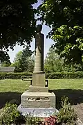 Monument 1870-1871
 -
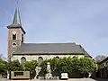 Church (Notre-Dame-de-l'Assomption)
 -
_monument_aux_morts.JPG) Monument 1914-1918
Monument 1914-1918
See also
References
- ^ "Répertoire national des élus: les maires" (in French). data.gouv.fr, Plateforme ouverte des données publiques françaises. 13 September 2022.
- ^ "Populations de référence 2022" (in French). The National Institute of Statistics and Economic Studies. 19 December 2024.
- ^ INSEE commune file
- ^ Population en historique depuis 1968, INSEE
Wikimedia Commons has media related to Gommegnies.