Ramousies
Ramousies | |
|---|---|
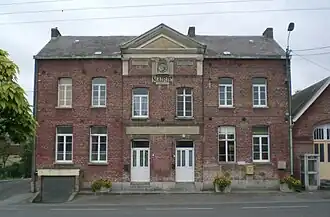 The town hall in Ramousies | |
.svg.png) Coat of arms | |
Location of Ramousies | |
 Ramousies  Ramousies | |
| Coordinates: 50°07′04″N 4°02′26″E / 50.1178°N 4.0406°E | |
| Country | France |
| Region | Hauts-de-France |
| Department | Nord |
| Arrondissement | Avesnes-sur-Helpe |
| Canton | Fourmies |
| Intercommunality | CC Cœur de l'Avesnois |
| Government | |
| • Mayor (2020–2026) | Brice Amand[1] |
Area 1 | 9.6 km2 (3.7 sq mi) |
| Population (2022)[2] | 224 |
| • Density | 23/km2 (60/sq mi) |
| Time zone | UTC+01:00 (CET) |
| • Summer (DST) | UTC+02:00 (CEST) |
| INSEE/Postal code | 59493 /59177 |
| Elevation | 152–221 m (499–725 ft) (avg. 165 m or 541 ft) |
| 1 French Land Register data, which excludes lakes, ponds, glaciers > 1 km2 (0.386 sq mi or 247 acres) and river estuaries. | |
Ramousies (French pronunciation: [ʁamuzi]) is a commune in the Nord department in northern France.[3]
Heraldry
|
The arms of Ramousies are blazoned : Bendy Or and gules. (Avesnes-sur-Helpe, Cartignies, Damousies, Dimechaux, Dimont, Felleries, Larouillies, Lomme, and use the same arms.)
|
See also
References
- ^ "Répertoire national des élus: les maires". data.gouv.fr, Plateforme ouverte des données publiques françaises (in French). 9 August 2021.
- ^ "Populations de référence 2022" (in French). The National Institute of Statistics and Economic Studies. 19 December 2024.
- ^ INSEE commune file
Wikimedia Commons has media related to Ramousies.