Horní Rápotice
Horní Rápotice | |
|---|---|
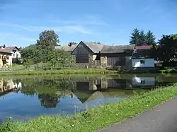 Centre of Horní Rápotice | |
 Flag  Coat of arms | |
 Horní Rápotice Location in the Czech Republic | |
| Coordinates: 49°34′31″N 15°19′14″E / 49.57528°N 15.32056°E | |
| Country | |
| Region | Vysočina |
| District | Pelhřimov |
| First mentioned | 1352 |
| Area | |
• Total | 3.98 km2 (1.54 sq mi) |
| Elevation | 551 m (1,808 ft) |
| Population (2025-01-01)[1] | |
• Total | 174 |
| • Density | 44/km2 (110/sq mi) |
| Time zone | UTC+1 (CET) |
| • Summer (DST) | UTC+2 (CEST) |
| Postal code | 396 01 |
| Website | hornirapotice |
Horní Rápotice is a municipality and village in Pelhřimov District in the Vysočina Region of the Czech Republic. It has about 200 inhabitants.
Demographics
| Year | Pop. | ±% |
|---|---|---|
| 1869 | 204 | — |
| 1880 | 227 | +11.3% |
| 1890 | 229 | +0.9% |
| 1900 | 215 | −6.1% |
| 1910 | 223 | +3.7% |
| 1921 | 227 | +1.8% |
| 1930 | 218 | −4.0% |
| 1950 | 170 | −22.0% |
| 1961 | 180 | +5.9% |
| 1970 | 166 | −7.8% |
| 1980 | 137 | −17.5% |
| 1991 | 128 | −6.6% |
| 2001 | 154 | +20.3% |
| 2011 | 157 | +1.9% |
| 2021 | 158 | +0.6% |
| Source: Censuses[2][3] | ||
References
- ^ "Population of Municipalities – 1 January 2025". Czech Statistical Office. 2025-05-16.
- ^ "Historický lexikon obcí České republiky 1869–2011" (in Czech). Czech Statistical Office. 2015-12-21.
- ^ "Population Census 2021: Population by sex". Public Database. Czech Statistical Office. 2021-03-27.
External links
Wikimedia Commons has media related to Horní Rápotice.