Proseč pod Křemešníkem
Proseč pod Křemešníkem | |
|---|---|
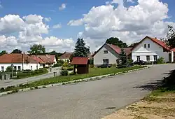 Centre of Proseč pod Křemešníkem | |
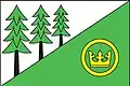 Flag  Coat of arms | |
 Proseč pod Křemešníkem Location in the Czech Republic | |
| Coordinates: 49°24′55″N 15°17′42″E / 49.41528°N 15.29500°E | |
| Country | |
| Region | Vysočina |
| District | Pelhřimov |
| First mentioned | 1379 |
| Area | |
• Total | 5.32 km2 (2.05 sq mi) |
| Elevation | 609 m (1,998 ft) |
| Population (2025-01-01)[1] | |
• Total | 91 |
| • Density | 17/km2 (44/sq mi) |
| Time zone | UTC+1 (CET) |
| • Summer (DST) | UTC+2 (CEST) |
| Postal code | 393 01 |
| Website | www |
Proseč pod Křemešníkem is a municipality and village in Pelhřimov District in the Vysočina Region of the Czech Republic. It has about 90 inhabitants.
Proseč pod Křemešníkem lies approximately 7 kilometres (4 mi) east of Pelhřimov, 22 km (14 mi) west of Jihlava, and 98 km (61 mi) south-east of Prague.
Demographics
| Year | Pop. | ±% |
|---|---|---|
| 1869 | 322 | — |
| 1880 | 312 | −3.1% |
| 1890 | 316 | +1.3% |
| 1900 | 268 | −15.2% |
| 1910 | 300 | +11.9% |
| 1921 | 297 | −1.0% |
| 1930 | 262 | −11.8% |
| 1950 | 175 | −33.2% |
| 1961 | 161 | −8.0% |
| 1970 | 143 | −11.2% |
| 1980 | 106 | −25.9% |
| 1991 | 75 | −29.2% |
| 2001 | 78 | +4.0% |
| 2011 | 84 | +7.7% |
| 2021 | 89 | +6.0% |
| Source: Censuses[2][3] | ||
References
- ^ "Population of Municipalities – 1 January 2025". Czech Statistical Office. 2025-05-16.
- ^ "Historický lexikon obcí České republiky 1869–2011" (in Czech). Czech Statistical Office. 2015-12-21.
- ^ "Population Census 2021: Population by sex". Public Database. Czech Statistical Office. 2021-03-27.
External links
Wikimedia Commons has media related to Proseč pod Křemešníkem.