Le Plagnal
Le Plagnal | |
|---|---|
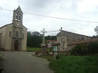 The church and cross in Le Plagnal | |
Location of Le Plagnal | |
 Le Plagnal  Le Plagnal | |
| Coordinates: 44°42′03″N 3°56′46″E / 44.7008°N 3.9461°E | |
| Country | France |
| Region | Auvergne-Rhône-Alpes |
| Department | Ardèche |
| Arrondissement | Largentière |
| Canton | Haute-Ardèche |
| Government | |
| • Mayor (2020–2026) | Denise Laffarre[1] |
Area 1 | 16.07 km2 (6.20 sq mi) |
| Population (2022)[2] | 65 |
| • Density | 4.0/km2 (10/sq mi) |
| Time zone | UTC+01:00 (CET) |
| • Summer (DST) | UTC+02:00 (CEST) |
| INSEE/Postal code | 07175 /07590 |
| Elevation | 1,056–1,463 m (3,465–4,800 ft) (avg. 1,160 m or 3,810 ft) |
| 1 French Land Register data, which excludes lakes, ponds, glaciers > 1 km2 (0.386 sq mi or 247 acres) and river estuaries. | |
Le Plagnal (French pronunciation: [lə plaɲal]; Occitan: Lo Planhau) is a commune in the Ardèche department in southern France.
Population
| Year | Pop. | ±% p.a. |
|---|---|---|
| 1968 | 104 | — |
| 1975 | 81 | −3.51% |
| 1982 | 69 | −2.26% |
| 1990 | 70 | +0.18% |
| 1999 | 53 | −3.04% |
| 2007 | 72 | +3.90% |
| 2012 | 55 | −5.24% |
| 2017 | 77 | +6.96% |
| Source: INSEE[3] | ||
See also
References
- ^ "Répertoire national des élus: les maires". data.gouv.fr, Plateforme ouverte des données publiques françaises (in French). 9 August 2021.
- ^ "Populations de référence 2022" (in French). The National Institute of Statistics and Economic Studies. 19 December 2024.
- ^ Population en historique depuis 1968, INSEE
Wikimedia Commons has media related to Le Plagnal.