Saint-Priest, Ardèche
Saint-Priest | |
|---|---|
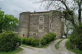 The château in Saint-Priest | |
Location of Saint-Priest | |
 Saint-Priest  Saint-Priest | |
| Coordinates: 44°43′02″N 4°32′49″E / 44.7172°N 4.5469°E | |
| Country | France |
| Region | Auvergne-Rhône-Alpes |
| Department | Ardèche |
| Arrondissement | Privas |
| Canton | Privas |
| Intercommunality | CA Privas Centre Ardèche |
| Government | |
| • Mayor (2020–2026) | Sandrine Chareyre[1] |
Area 1 | 19.15 km2 (7.39 sq mi) |
| Population (2022)[2] | 1,337 |
| • Density | 70/km2 (180/sq mi) |
| Time zone | UTC+01:00 (CET) |
| • Summer (DST) | UTC+02:00 (CEST) |
| INSEE/Postal code | 07288 /07000 |
| Elevation | 278–1,019 m (912–3,343 ft) (avg. 420 m or 1,380 ft) |
| 1 French Land Register data, which excludes lakes, ponds, glaciers > 1 km2 (0.386 sq mi or 247 acres) and river estuaries. | |
Saint-Priest (French pronunciation: [sɛ̃ pʁi(jɛst)]; Occitan: Sant Preste) is a commune in the Ardèche department in southern France.
Population
| Year | Pop. | ±% |
|---|---|---|
| 1962 | 481 | — |
| 1968 | 486 | +1.0% |
| 1975 | 550 | +13.2% |
| 1982 | 749 | +36.2% |
| 1990 | 968 | +29.2% |
| 1999 | 1,107 | +14.4% |
| 2008 | 1,231 | +11.2% |
See also
References
- ^ "Répertoire national des élus: les maires" (in French). data.gouv.fr, Plateforme ouverte des données publiques françaises. 13 September 2022.
- ^ "Populations de référence 2022" (in French). The National Institute of Statistics and Economic Studies. 19 December 2024.
Wikimedia Commons has media related to Saint-Priest (Ardèche).