Řepice
Řepice | |
|---|---|
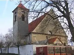 Church of Saint Mary Magdalene | |
 Flag  Coat of arms | |
 Řepice Location in the Czech Republic | |
| Coordinates: 49°16′50″N 13°56′0″E / 49.28056°N 13.93333°E | |
| Country | |
| Region | South Bohemian |
| District | Strakonice |
| First mentioned | 1251 |
| Area | |
• Total | 4.28 km2 (1.65 sq mi) |
| Elevation | 423 m (1,388 ft) |
| Population (2025-01-01)[1] | |
• Total | 442 |
| • Density | 100/km2 (270/sq mi) |
| Time zone | UTC+1 (CET) |
| • Summer (DST) | UTC+2 (CEST) |
| Postal code | 386 01 |
| Website | www |
Řepice (German: Repitz) is a municipality and village in Strakonice District in the South Bohemian Region of the Czech Republic. It has about 400 inhabitants.
Řepice lies approximately 4 kilometres (2 mi) north-east of Strakonice, 53 km (33 mi) north-west of České Budějovice, and 97 km (60 mi) south of Prague.
Demographics
| Year | Pop. | ±% |
|---|---|---|
| 1869 | 354 | — |
| 1880 | 417 | +17.8% |
| 1890 | 363 | −12.9% |
| 1900 | 316 | −12.9% |
| 1910 | 334 | +5.7% |
| 1921 | 358 | +7.2% |
| 1930 | 335 | −6.4% |
| 1950 | 293 | −12.5% |
| 1961 | 314 | +7.2% |
| 1970 | 311 | −1.0% |
| 1980 | 290 | −6.8% |
| 1991 | 235 | −19.0% |
| 2001 | 292 | +24.3% |
| 2011 | 455 | +55.8% |
| 2021 | 461 | +1.3% |
| Source: Censuses[2][3] | ||
References
- ^ "Population of Municipalities – 1 January 2025". Czech Statistical Office. 2025-05-16.
- ^ "Historický lexikon obcí České republiky 1869–2011" (in Czech). Czech Statistical Office. 2015-12-21.
- ^ "Population Census 2021: Population by sex". Public Database. Czech Statistical Office. 2021-03-27.
External links
Wikimedia Commons has media related to Řepice.