Drahonice
Drahonice | |
|---|---|
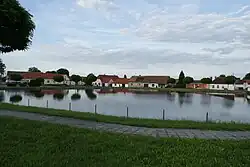 Centre of Drahonice | |
 Flag 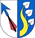 Coat of arms | |
 Drahonice Location in the Czech Republic | |
| Coordinates: 49°12′3″N 14°4′29″E / 49.20083°N 14.07472°E | |
| Country | |
| Region | South Bohemian |
| District | Strakonice |
| First mentioned | 1240 |
| Area | |
• Total | 12.72 km2 (4.91 sq mi) |
| Elevation | 468 m (1,535 ft) |
| Population (2025-01-01)[1] | |
• Total | 413 |
| • Density | 32/km2 (84/sq mi) |
| Time zone | UTC+1 (CET) |
| • Summer (DST) | UTC+2 (CEST) |
| Postal code | 389 01 |
| Website | www |
Drahonice is a municipality and village in Strakonice District in the South Bohemian Region of the Czech Republic. It has about 400 inhabitants.
Drahonice lies approximately 15 kilometres (9 mi) south-east of Strakonice, 39 km (24 mi) north-west of České Budějovice, and 102 km (63 mi) south of Prague.
Administrative division
Drahonice consists of two municipal parts (in brackets population according to the 2021 census):[2]
- Drahonice (291)
- Albrechtice (98)
Demographics
| Year | Pop. | ±% |
|---|---|---|
| 1869 | 670 | — |
| 1880 | 663 | −1.0% |
| 1890 | 611 | −7.8% |
| 1900 | 631 | +3.3% |
| 1910 | 681 | +7.9% |
| 1921 | 675 | −0.9% |
| 1930 | 613 | −9.2% |
| 1950 | 485 | −20.9% |
| 1961 | 489 | +0.8% |
| 1970 | 428 | −12.5% |
| 1980 | 424 | −0.9% |
| 1991 | 365 | −13.9% |
| 2001 | 370 | +1.4% |
| 2011 | 348 | −5.9% |
| 2021 | 389 | +11.8% |
| Source: Censuses[3][4] | ||
References
- ^ "Population of Municipalities – 1 January 2025". Czech Statistical Office. 2025-05-16.
- ^ "Public Census 2021 – basic data". Public Database (in Czech). Czech Statistical Office. 2022.
- ^ "Historický lexikon obcí České republiky 1869–2011" (in Czech). Czech Statistical Office. 2015-12-21.
- ^ "Population Census 2021: Population by sex". Public Database. Czech Statistical Office. 2021-03-27.
External links
Wikimedia Commons has media related to Drahonice.