Mečichov
Mečichov | |
|---|---|
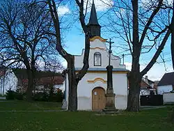 Chapel of Saint Adalbert | |
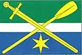 Flag  Coat of arms | |
 Mečichov Location in the Czech Republic | |
| Coordinates: 49°20′52″N 13°48′43″E / 49.34778°N 13.81194°E | |
| Country | |
| Region | South Bohemian |
| District | Strakonice |
| First mentioned | 1539 |
| Area | |
• Total | 8.86 km2 (3.42 sq mi) |
| Elevation | 494 m (1,621 ft) |
| Population (2025-01-01)[1] | |
• Total | 285 |
| • Density | 32/km2 (83/sq mi) |
| Time zone | UTC+1 (CET) |
| • Summer (DST) | UTC+2 (CEST) |
| Postal code | 387 36 |
| Website | mecichov |
Mečichov is a municipality and village in Strakonice District in the South Bohemian Region of the Czech Republic. It has about 300 inhabitants.
Mečichov lies approximately 13 kilometres (8 mi) north-west of Strakonice, 65 km (40 mi) north-west of České Budějovice, and 94 km (58 mi) south-west of Prague.
Demographics
| Year | Pop. | ±% |
|---|---|---|
| 1869 | 511 | — |
| 1880 | 580 | +13.5% |
| 1890 | 555 | −4.3% |
| 1900 | 551 | −0.7% |
| 1910 | 542 | −1.6% |
| 1921 | 565 | +4.2% |
| 1930 | 509 | −9.9% |
| 1950 | 400 | −21.4% |
| 1961 | 379 | −5.2% |
| 1970 | 335 | −11.6% |
| 1980 | 330 | −1.5% |
| 1991 | 283 | −14.2% |
| 2001 | 246 | −13.1% |
| 2011 | 249 | +1.2% |
| 2021 | 272 | +9.2% |
| Source: Censuses[2][3] | ||
References
- ^ "Population of Municipalities – 1 January 2025". Czech Statistical Office. 2025-05-16.
- ^ "Historický lexikon obcí České republiky 1869–2011" (in Czech). Czech Statistical Office. 2015-12-21.
- ^ "Population Census 2021: Population by sex". Public Database. Czech Statistical Office. 2021-03-27.
External links
Wikimedia Commons has media related to Mečichov.