Droužetice
Droužetice | |
|---|---|
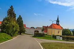 Chapel in the centre of Droužetice | |
 Flag  Coat of arms | |
 Droužetice Location in the Czech Republic | |
| Coordinates: 49°17′21″N 13°53′53″E / 49.28917°N 13.89806°E | |
| Country | |
| Region | South Bohemian |
| District | Strakonice |
| First mentioned | 1227 |
| Area | |
• Total | 5.21 km2 (2.01 sq mi) |
| Elevation | 440 m (1,440 ft) |
| Population (2025-01-01)[1] | |
• Total | 130 |
| • Density | 25/km2 (65/sq mi) |
| Time zone | UTC+1 (CET) |
| • Summer (DST) | UTC+2 (CEST) |
| Postal code | 386 01 |
| Website | www |
Droužetice is a municipality and village in Strakonice District in the South Bohemian Region of the Czech Republic. It has about 100 inhabitants.
Droužetice lies approximately 4 kilometres (2 mi) north of Strakonice, 55 km (34 mi) north-west of České Budějovice, and 97 km (60 mi) south-west of Prague.
Administrative division
Droužetice consists of two municipal parts (in brackets population according to the 2021 census):[2]
- Droužetice (114)
- Černíkov (22)
Demographics
| Year | Pop. | ±% |
|---|---|---|
| 1869 | 277 | — |
| 1880 | 281 | +1.4% |
| 1890 | 244 | −13.2% |
| 1900 | 247 | +1.2% |
| 1910 | 265 | +7.3% |
| 1921 | 248 | −6.4% |
| 1930 | 243 | −2.0% |
| 1950 | 185 | −23.9% |
| 1961 | 174 | −5.9% |
| 1970 | 166 | −4.6% |
| 1980 | 127 | −23.5% |
| 1991 | 116 | −8.7% |
| 2001 | 107 | −7.8% |
| 2011 | 101 | −5.6% |
| 2021 | 136 | +34.7% |
| Source: Censuses[3][4] | ||
References
- ^ "Population of Municipalities – 1 January 2025". Czech Statistical Office. 2025-05-16.
- ^ "Public Census 2021 – basic data". Public Database (in Czech). Czech Statistical Office. 2022.
- ^ "Historický lexikon obcí České republiky 1869–2011" (in Czech). Czech Statistical Office. 2015-12-21.
- ^ "Population Census 2021: Population by sex". Public Database. Czech Statistical Office. 2021-03-27.
External links
Wikimedia Commons has media related to Droužetice.