Štěpkov
Štěpkov | |
|---|---|
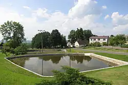 Centre of Štěpkov | |
 Flag  Coat of arms | |
 Štěpkov Location in the Czech Republic | |
| Coordinates: 49°5′3″N 15°39′0″E / 49.08417°N 15.65000°E | |
| Country | |
| Region | Vysočina |
| District | Třebíč |
| First mentioned | 1351 |
| Area | |
• Total | 3.93 km2 (1.52 sq mi) |
| Elevation | 565 m (1,854 ft) |
| Population (2025-01-01)[1] | |
• Total | 111 |
| • Density | 28/km2 (73/sq mi) |
| Time zone | UTC+1 (CET) |
| • Summer (DST) | UTC+2 (CEST) |
| Postal code | 675 26 |
| Website | www |
Štěpkov is a municipality and village in Třebíč District in the Vysočina Region of the Czech Republic. It has about 100 inhabitants.
Štěpkov lies approximately 23 kilometres (14 mi) south-west of Třebíč, 36 km (22 mi) south of Jihlava, and 143 km (89 mi) south-east of Prague.
Demographics
| Year | Pop. | ±% |
|---|---|---|
| 1869 | 222 | — |
| 1880 | 245 | +10.4% |
| 1890 | 229 | −6.5% |
| 1900 | 234 | +2.2% |
| 1910 | 243 | +3.8% |
| 1921 | 234 | −3.7% |
| 1930 | 254 | +8.5% |
| 1950 | 181 | −28.7% |
| 1961 | 173 | −4.4% |
| 1970 | 149 | −13.9% |
| 1980 | 142 | −4.7% |
| 1991 | 128 | −9.9% |
| 2001 | 114 | −10.9% |
| 2011 | 114 | +0.0% |
| 2021 | 113 | −0.9% |
| Source: Censuses[2][3] | ||
References
- ^ "Population of Municipalities – 1 January 2025". Czech Statistical Office. 16 May 2025.
- ^ "Historický lexikon obcí České republiky 1869–2011" (in Czech). Czech Statistical Office. 21 December 2015.
- ^ "Population Census 2021: Population by sex". Public Database. Czech Statistical Office. 27 March 2021.
External links
Wikimedia Commons has media related to Štěpkov.