Stropešín
Stropešín | |
|---|---|
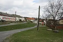 Centre of Stropešín | |
 Flag  Coat of arms | |
 Stropešín Location in the Czech Republic | |
| Coordinates: 49°9′15″N 16°4′38″E / 49.15417°N 16.07722°E | |
| Country | |
| Region | Vysočina |
| District | Třebíč |
| First mentioned | 1125 |
| Area | |
• Total | 6.90 km2 (2.66 sq mi) |
| Elevation | 438 m (1,437 ft) |
| Population (2025-01-01)[1] | |
• Total | 126 |
| • Density | 18/km2 (47/sq mi) |
| Time zone | UTC+1 (CET) |
| • Summer (DST) | UTC+2 (CEST) |
| Postal code | 675 55 |
| Website | www |
Stropešín is a municipality and village in Třebíč District in the Vysočina Region of the Czech Republic. It has about 100 inhabitants.
Stropešín lies approximately 17 kilometres (11 mi) south-east of Třebíč, 45 km (28 mi) south-east of Jihlava, and 159 km (99 mi) south-east of Prague.
Demographics
| Year | Pop. | ±% |
|---|---|---|
| 1869 | 211 | — |
| 1880 | 200 | −5.2% |
| 1890 | 240 | +20.0% |
| 1900 | 244 | +1.7% |
| 1910 | 244 | +0.0% |
| 1921 | 238 | −2.5% |
| 1930 | 261 | +9.7% |
| 1950 | 199 | −23.8% |
| 1961 | 225 | +13.1% |
| 1970 | 193 | −14.2% |
| 1980 | 162 | −16.1% |
| 1991 | 143 | −11.7% |
| 2001 | 125 | −12.6% |
| 2011 | 116 | −7.2% |
| 2021 | 123 | +6.0% |
| Source: Censuses[2][3] | ||
References
- ^ "Population of Municipalities – 1 January 2025". Czech Statistical Office. 2025-05-16.
- ^ "Historický lexikon obcí České republiky 1869–2011" (in Czech). Czech Statistical Office. 2015-12-21.
- ^ "Population Census 2021: Population by sex". Public Database. Czech Statistical Office. 2021-03-27.
External links
Wikimedia Commons has media related to Stropešín.