Lovčovice
Lovčovice | |
|---|---|
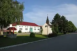 Centre of Lovčovice | |
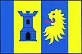 Flag  Coat of arms | |
 Lovčovice Location in the Czech Republic | |
| Coordinates: 48°58′54″N 15°32′4″E / 48.98167°N 15.53444°E | |
| Country | |
| Region | Vysočina |
| District | Třebíč |
| First mentioned | 1351 |
| Area | |
• Total | 3.90 km2 (1.51 sq mi) |
| Elevation | 454 m (1,490 ft) |
| Population (2025-01-01)[1] | |
• Total | 63 |
| • Density | 16/km2 (42/sq mi) |
| Time zone | UTC+1 (CET) |
| • Summer (DST) | UTC+2 (CEST) |
| Postal code | 675 31 |
| Website | www |
Lovčovice is a municipality and village in Třebíč District in the Vysočina Region of the Czech Republic. It has about 60 inhabitants.
Lovčovice lies approximately 37 kilometres (23 mi) south-west of Třebíč, 47 km (29 mi) south of Jihlava, and 148 km (92 mi) south-east of Prague.
Demographics
| Year | Pop. | ±% |
|---|---|---|
| 1869 | 119 | — |
| 1880 | 110 | −7.6% |
| 1890 | 113 | +2.7% |
| 1900 | 125 | +10.6% |
| 1910 | 117 | −6.4% |
| 1921 | 136 | +16.2% |
| 1930 | 134 | −1.5% |
| 1950 | 72 | −46.3% |
| 1961 | 70 | −2.8% |
| 1970 | 78 | +11.4% |
| 1980 | 77 | −1.3% |
| 1991 | 71 | −7.8% |
| 2001 | 64 | −9.9% |
| 2011 | 56 | −12.5% |
| 2021 | 63 | +12.5% |
| Source: Censuses[2][3] | ||
References
- ^ "Population of Municipalities – 1 January 2025". Czech Statistical Office. 2025-05-16.
- ^ "Historický lexikon obcí České republiky 1869–2011" (in Czech). Czech Statistical Office. 2015-12-21.
- ^ "Population Census 2021: Population by sex". Public Database. Czech Statistical Office. 2021-03-27.
External links
Wikimedia Commons has media related to Lovčovice.