Výčapy
Výčapy | |
|---|---|
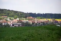 General view | |
 Flag  Coat of arms | |
 Výčapy Location in the Czech Republic | |
| Coordinates: 49°8′37″N 15°52′39″E / 49.14361°N 15.87750°E | |
| Country | |
| Region | Vysočina |
| District | Třebíč |
| First mentioned | 1104 |
| Area | |
• Total | 13.36 km2 (5.16 sq mi) |
| Elevation | 478 m (1,568 ft) |
| Population (2025-01-01)[1] | |
• Total | 855 |
| • Density | 64/km2 (170/sq mi) |
| Time zone | UTC+1 (CET) |
| • Summer (DST) | UTC+2 (CEST) |
| Postal code | 674 01 |
| Website | www |
Výčapy is a municipality and village in Třebíč District in the Vysočina Region of the Czech Republic. It has about 900 inhabitants.
Výčapy lies approximately 9 kilometres (6 mi) south of Třebíč, 35 km (22 mi) south-east of Jihlava, and 149 km (93 mi) south-east of Prague.
Administrative division
Výčapy consists of two municipal parts (in brackets population according to the 2021 census):[2]
- Výčapy (691)
- Štěpánovice (141)
Demographics
| Year | Pop. | ±% |
|---|---|---|
| 1869 | 582 | — |
| 1880 | 655 | +12.5% |
| 1890 | 674 | +2.9% |
| 1900 | 681 | +1.0% |
| 1910 | 690 | +1.3% |
| 1921 | 699 | +1.3% |
| 1930 | 710 | +1.6% |
| 1950 | 658 | −7.3% |
| 1961 | 665 | +1.1% |
| 1970 | 650 | −2.3% |
| 1980 | 703 | +8.2% |
| 1991 | 719 | +2.3% |
| 2001 | 773 | +7.5% |
| 2011 | 824 | +6.6% |
| 2021 | 832 | +1.0% |
| Source: Censuses[3][4] | ||
References
- ^ "Population of Municipalities – 1 January 2025". Czech Statistical Office. 2025-05-16.
- ^ "Public Census 2021 – basic data". Public Database (in Czech). Czech Statistical Office. 2022.
- ^ "Historický lexikon obcí České republiky 1869–2011" (in Czech). Czech Statistical Office. 2015-12-21.
- ^ "Population Census 2021: Population by sex". Public Database. Czech Statistical Office. 2021-03-27.
External links
Wikimedia Commons has media related to Výčapy.