Chotěbudice
Chotěbudice | |
|---|---|
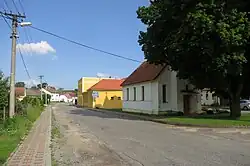 Centre of Chotěbudice | |
 Chotěbudice Location in the Czech Republic | |
| Coordinates: 49°3′29″N 15°34′26″E / 49.05806°N 15.57389°E | |
| Country | |
| Region | Vysočina |
| District | Třebíč |
| First mentioned | 1351 |
| Area | |
• Total | 5.51 km2 (2.13 sq mi) |
| Elevation | 480 m (1,570 ft) |
| Population (2025-01-01)[1] | |
• Total | 104 |
| • Density | 19/km2 (49/sq mi) |
| Time zone | UTC+1 (CET) |
| • Summer (DST) | UTC+2 (CEST) |
| Postal code | 675 31 |
| Website | www |
Chotěbudice (German: Dreieichen) is a municipality and village in Třebíč District in the Vysočina Region of the Czech Republic. It has about 100 inhabitants.
Chotěbudice lies approximately 29 kilometres (18 mi) south-west of Třebíč, 38 km (24 mi) south of Jihlava, and 142 km (88 mi) south-east of Prague.
Demographics
| Year | Pop. | ±% |
|---|---|---|
| 1869 | 298 | — |
| 1880 | 298 | +0.0% |
| 1890 | 282 | −5.4% |
| 1900 | 295 | +4.6% |
| 1910 | 316 | +7.1% |
| 1921 | 299 | −5.4% |
| 1930 | 270 | −9.7% |
| 1950 | 227 | −15.9% |
| 1961 | 177 | −22.0% |
| 1970 | 167 | −5.6% |
| 1980 | 145 | −13.2% |
| 1991 | 114 | −21.4% |
| 2001 | 112 | −1.8% |
| 2011 | 100 | −10.7% |
| 2021 | 101 | +1.0% |
| Source: Censuses[2][3] | ||
References
- ^ "Population of Municipalities – 1 January 2025". Czech Statistical Office. 2025-05-16.
- ^ "Historický lexikon obcí České republiky 1869–2011" (in Czech). Czech Statistical Office. 2015-12-21.
- ^ "Population Census 2021: Population by sex". Public Database. Czech Statistical Office. 2021-03-27.
External links
Wikimedia Commons has media related to Chotěbudice.