Lusignac
Lusignac | |
|---|---|
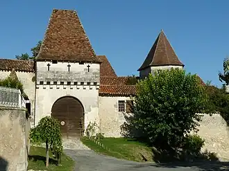 Chateau | |
.svg.png) Coat of arms | |
Location of Lusignac | |
 Lusignac  Lusignac | |
| Coordinates: 45°19′41″N 0°18′45″E / 45.3281°N 0.3125°E | |
| Country | France |
| Region | Nouvelle-Aquitaine |
| Department | Dordogne |
| Arrondissement | Périgueux |
| Canton | Ribérac |
| Government | |
| • Mayor (2020–2026) | Ludovic Gillaizeau[1] |
Area 1 | 7.88 km2 (3.04 sq mi) |
| Population (2022)[2] | 163 |
| • Density | 21/km2 (54/sq mi) |
| Time zone | UTC+01:00 (CET) |
| • Summer (DST) | UTC+02:00 (CEST) |
| INSEE/Postal code | 24247 /24320 |
| Elevation | 62–184 m (203–604 ft) (avg. 150 m or 490 ft) |
| 1 French Land Register data, which excludes lakes, ponds, glaciers > 1 km2 (0.386 sq mi or 247 acres) and river estuaries. | |
Lusignac (French pronunciation: [lyziɲak]; Occitan: Lusinhac) is a commune in the Dordogne department in Nouvelle-Aquitaine in southwestern France.
Population
| Year | Pop. | ±% |
|---|---|---|
| 1962 | 239 | — |
| 1968 | 210 | −12.1% |
| 1975 | 201 | −4.3% |
| 1982 | 192 | −4.5% |
| 1990 | 192 | +0.0% |
| 1999 | 185 | −3.6% |
| 2008 | 186 | +0.5% |
See also
References
- ^ "Répertoire national des élus: les maires". data.gouv.fr, Plateforme ouverte des données publiques françaises (in French). 9 August 2021.
- ^ "Populations de référence 2022" (in French). The National Institute of Statistics and Economic Studies. 19 December 2024.
Wikimedia Commons has media related to Lusignac.