Couleuvre
Couleuvre | |
|---|---|
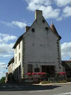 The museum in Couleuvre | |
Location of Couleuvre | |
 Couleuvre  Couleuvre | |
| Coordinates: 46°40′22″N 2°54′30″E / 46.6728°N 2.9083°E | |
| Country | France |
| Region | Auvergne-Rhône-Alpes |
| Department | Allier |
| Arrondissement | Montluçon |
| Canton | Bourbon-l'Archambault |
| Intercommunality | CC du Pays de Tronçais |
| Government | |
| • Mayor (2020–2026) | Daniel Rondet[1] |
Area 1 | 53.83 km2 (20.78 sq mi) |
| Population (2022)[2] | 592 |
| • Density | 11/km2 (28/sq mi) |
| Time zone | UTC+01:00 (CET) |
| • Summer (DST) | UTC+02:00 (CEST) |
| INSEE/Postal code | 03087 /03320 |
| Elevation | 207–317 m (679–1,040 ft) (avg. 236 m or 774 ft) |
| 1 French Land Register data, which excludes lakes, ponds, glaciers > 1 km2 (0.386 sq mi or 247 acres) and river estuaries. | |
Couleuvre (French pronunciation: [kulœvʁ]) is a commune in the department of Allier in Auvergne in central France.
Population
| Year | Pop. | ±% p.a. |
|---|---|---|
| 1968 | 1,126 | — |
| 1975 | 900 | −3.15% |
| 1982 | 796 | −1.74% |
| 1990 | 716 | −1.32% |
| 1999 | 645 | −1.15% |
| 2009 | 584 | −0.99% |
| 2014 | 560 | −0.84% |
| 2020 | 597 | +1.07% |
| Source: INSEE[3] | ||
See also
References
- ^ "Répertoire national des élus: les maires" (in French). data.gouv.fr, Plateforme ouverte des données publiques françaises. 13 September 2022.
- ^ "Populations de référence 2022" (in French). The National Institute of Statistics and Economic Studies. 19 December 2024.
- ^ Population en historique depuis 1968, INSEE
External links
Wikimedia Commons has media related to Couleuvre.