Jaulny
Jaulny | |
|---|---|
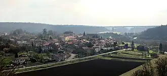 Jaulny, seen from next to the Hailbat virgin. In the background: the viaduct of the LGV-Est | |
 Coat of arms | |
Location of Jaulny | |
 Jaulny  Jaulny | |
| Coordinates: 48°58′18″N 5°53′15″E / 48.9717°N 5.8875°E | |
| Country | France |
| Region | Grand Est |
| Department | Meurthe-et-Moselle |
| Arrondissement | Toul |
| Canton | Le Nord-Toulois |
| Intercommunality | Mad et Moselle |
| Government | |
| • Mayor (2020–2026) | Corinne Halteur[1] |
Area 1 | 8.25 km2 (3.19 sq mi) |
| Population (2022)[2] | 200 |
| • Density | 24/km2 (63/sq mi) |
| Demonym | Jaulnois(e)s |
| Time zone | UTC+01:00 (CET) |
| • Summer (DST) | UTC+02:00 (CEST) |
| INSEE/Postal code | 54275 /54470 |
| Elevation | 194–318 m (636–1,043 ft) (avg. 200 m or 660 ft) |
| 1 French Land Register data, which excludes lakes, ponds, glaciers > 1 km2 (0.386 sq mi or 247 acres) and river estuaries. | |
Jaulny (French pronunciation: [ʒo(l)ni]) is a commune in the Meurthe-et-Moselle department in north-eastern France.
Geography
The village lies in the middle of the commune, on the right bank of the Rupt de Mad, which flows northward through the commune.
See also
References
- ^ "Répertoire national des élus: les maires" (in French). data.gouv.fr, Plateforme ouverte des données publiques françaises. 13 September 2022.
- ^ "Populations de référence 2022" (in French). The National Institute of Statistics and Economic Studies. 19 December 2024.
Wikimedia Commons has media related to Jaulny.