Vandelainville
Vandelainville | |
|---|---|
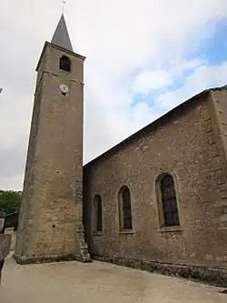 The church in Vandelainville | |
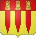 Coat of arms | |
Location of Vandelainville | |
 Vandelainville  Vandelainville | |
| Coordinates: 49°01′03″N 5°58′38″E / 49.0175°N 5.9772°E | |
| Country | France |
| Region | Grand Est |
| Department | Meurthe-et-Moselle |
| Arrondissement | Toul |
| Canton | Pont-à-Mousson |
| Intercommunality | Mad et Moselle |
| Government | |
| • Mayor (2020–2026) | Jean-Louis Depierreux[1] |
Area 1 | 1.36 km2 (0.53 sq mi) |
| Population (2022)[2] | 142 |
| • Density | 100/km2 (270/sq mi) |
| Time zone | UTC+01:00 (CET) |
| • Summer (DST) | UTC+02:00 (CEST) |
| INSEE/Postal code | 54544 /54890 |
| Elevation | 182–366 m (597–1,201 ft) (avg. 195 m or 640 ft) |
| 1 French Land Register data, which excludes lakes, ponds, glaciers > 1 km2 (0.386 sq mi or 247 acres) and river estuaries. | |
Vandelainville (French pronunciation: [vɑ̃dlɛ̃vil]) is a commune in the Meurthe-et-Moselle department in north-eastern France.
Geography
The village lies on the left bank of the Rupt de Mad, which forms most of the commune's southern border.
See also
References
- ^ "Répertoire national des élus: les maires". data.gouv.fr, Plateforme ouverte des données publiques françaises (in French). 2 December 2020.
- ^ "Populations de référence 2022" (in French). The National Institute of Statistics and Economic Studies. 19 December 2024.
Wikimedia Commons has media related to Vandelainville.