Saint-Sauveur, Meurthe-et-Moselle
Saint-Sauveur | |
|---|---|
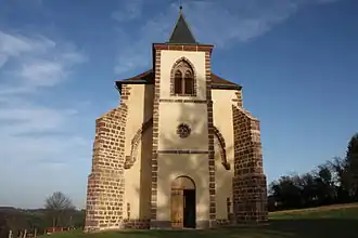 The former abbey church in Saint-Sauveur | |
.svg.png) Coat of arms | |
Location of Saint-Sauveur | |
 Saint-Sauveur  Saint-Sauveur | |
| Coordinates: 48°32′04″N 6°58′28″E / 48.5344°N 6.9744°E | |
| Country | France |
| Region | Grand Est |
| Department | Meurthe-et-Moselle |
| Arrondissement | Lunéville |
| Canton | Baccarat |
| Government | |
| • Mayor (2020–2026) | Philippe Arnould[1] |
Area 1 | 19.16 km2 (7.40 sq mi) |
| Population (2022)[2] | 40 |
| • Density | 2.1/km2 (5.4/sq mi) |
| Time zone | UTC+01:00 (CET) |
| • Summer (DST) | UTC+02:00 (CEST) |
| INSEE/Postal code | 54488 /54480 |
| Elevation | 315–715 m (1,033–2,346 ft) (avg. 400 m or 1,300 ft) |
| 1 French Land Register data, which excludes lakes, ponds, glaciers > 1 km2 (0.386 sq mi or 247 acres) and river estuaries. | |
Saint-Sauveur (French pronunciation: [sɛ̃ sovœʁ] ⓘ) is a commune in the Meurthe-et-Moselle department in north-eastern France.[3]
See also
References
- ^ "Répertoire national des élus: les maires". data.gouv.fr, Plateforme ouverte des données publiques françaises (in French). 2 December 2020.
- ^ "Populations de référence 2022" (in French). The National Institute of Statistics and Economic Studies. 19 December 2024.
- ^ INSEE commune file
Wikimedia Commons has media related to Saint-Sauveur (Meurthe-et-Moselle).