Nivollet-Montgriffon
Nivollet-Montgriffon | |
|---|---|
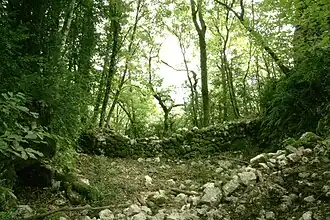 Ruins of the chateau | |
Location of Nivollet-Montgriffon | |
 Nivollet-Montgriffon  Nivollet-Montgriffon | |
| Coordinates: 45°59′00″N 5°26′00″E / 45.9833°N 5.4333°E | |
| Country | France |
| Region | Auvergne-Rhône-Alpes |
| Department | Ain |
| Arrondissement | Belley |
| Canton | Ambérieu-en-Bugey |
| Government | |
| • Mayor (2023–2026) | Emmanuel Simonnet[1] |
Area 1 | 8.24 km2 (3.18 sq mi) |
| Population (2022)[2] | 119 |
| • Density | 14/km2 (37/sq mi) |
| Time zone | UTC+01:00 (CET) |
| • Summer (DST) | UTC+02:00 (CEST) |
| INSEE/Postal code | 01277 /01230 |
| Elevation | 440–833 m (1,444–2,733 ft) (avg. 598 m or 1,962 ft) |
| 1 French Land Register data, which excludes lakes, ponds, glaciers > 1 km2 (0.386 sq mi or 247 acres) and river estuaries. | |
Nivollet-Montgriffon (French pronunciation: [nivɔlɛ mɔ̃ɡʁifɔ̃] ⓘ) is a commune in the Ain department in eastern France.
Population
| Year | Pop. | ±% p.a. |
|---|---|---|
| 1968 | 103 | — |
| 1975 | 81 | −3.37% |
| 1982 | 63 | −3.53% |
| 1990 | 66 | +0.58% |
| 1999 | 87 | +3.12% |
| 2009 | 140 | +4.87% |
| 2014 | 119 | −3.20% |
| 2020 | 115 | −0.57% |
| Source: INSEE[3] | ||
See also
References
- ^ "Répertoire national des élus: les maires" (in French). data.gouv.fr, Plateforme ouverte des données publiques françaises. 6 June 2023. Archived from the original on 28 June 2020. Retrieved 6 May 2024.
- ^ "Populations de référence 2022" (in French). The National Institute of Statistics and Economic Studies. 19 December 2024.
- ^ Population en historique depuis 1968 Archived 10 December 2023 at the Wayback Machine, INSEE
Wikimedia Commons has media related to Nivollet-Montgriffon.