Vitrac, Cantal
Vitrac | |
|---|---|
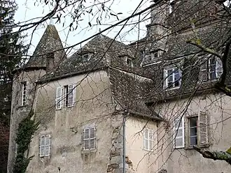 The Chateau de Fargues, in Vitrac | |
Location of Vitrac | |
 Vitrac  Vitrac | |
| Coordinates: 44°48′58″N 2°18′56″E / 44.8161°N 2.3156°E | |
| Country | France |
| Region | Auvergne-Rhône-Alpes |
| Department | Cantal |
| Arrondissement | Aurillac |
| Canton | Maurs |
| Government | |
| • Mayor (2020–2026) | Marie-Paule Bouquier[1] |
Area 1 | 17.88 km2 (6.90 sq mi) |
| Population (2022)[2] | 269 |
| • Density | 15/km2 (39/sq mi) |
| Time zone | UTC+01:00 (CET) |
| • Summer (DST) | UTC+02:00 (CEST) |
| INSEE/Postal code | 15264 /15220 |
| Elevation | 444–786 m (1,457–2,579 ft) (avg. 550 m or 1,800 ft) |
| 1 French Land Register data, which excludes lakes, ponds, glaciers > 1 km2 (0.386 sq mi or 247 acres) and river estuaries. | |
Vitrac (French pronunciation: [vitʁak]) is a commune in the Cantal department in south-central France.
Population
| Year | Pop. | ±% |
|---|---|---|
| 1962 | 395 | — |
| 1968 | 409 | +3.5% |
| 1975 | 404 | −1.2% |
| 1982 | 347 | −14.1% |
| 1990 | 294 | −15.3% |
| 1999 | 277 | −5.8% |
| 2008 | 293 | +5.8% |
See also
References
- ^ "Répertoire national des élus: les maires". data.gouv.fr, Plateforme ouverte des données publiques françaises (in French). 2 December 2020.
- ^ "Populations de référence 2022" (in French). The National Institute of Statistics and Economic Studies. 19 December 2024.
Wikimedia Commons has media related to Vitrac (Cantal).