Crulai
Crulai | |
|---|---|
 | |
 Coat of arms | |
Location of Crulai | |
 Crulai  Crulai | |
| Coordinates: 48°42′19″N 0°40′03″E / 48.7053°N 0.6675°E | |
| Country | France |
| Region | Normandy |
| Department | Orne |
| Arrondissement | Mortagne-au-Perche |
| Canton | Tourouvre au Perche |
| Intercommunality | CC du Pays de l'Aigle |
| Government | |
| • Mayor (2020–2026) | Philippe Croteau[1] |
Area 1 | 22.50 km2 (8.69 sq mi) |
| Population (2022)[2] | 803 |
| • Density | 36/km2 (92/sq mi) |
| Time zone | UTC+01:00 (CET) |
| • Summer (DST) | UTC+02:00 (CEST) |
| INSEE/Postal code | 61140 /61300 |
| Elevation | 204–264 m (669–866 ft) (avg. 230 m or 750 ft) |
| 1 French Land Register data, which excludes lakes, ponds, glaciers > 1 km2 (0.386 sq mi or 247 acres) and river estuaries. | |
Crulai (French pronunciation: [kʁylɛ] ⓘ) is a commune in the Orne department in north-western France.
Geography
The Commune along with another 70 communes shares part of a 47,681 hectare, Natura 2000 conservation area, called the Forêts et étangs du Perche.[3]
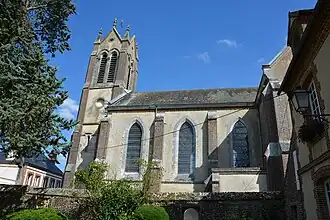
Points of interest
National heritage sites
- Cornillère Farm a nineteenth century model farm, that was registered as a Monument historique 2006.[4]
See also
References
- ^ "Répertoire national des élus: les maires". data.gouv.fr, Plateforme ouverte des données publiques françaises (in French). 9 August 2021.
- ^ "Populations de référence 2022" (in French). The National Institute of Statistics and Economic Studies. 19 December 2024.
- ^ "INPN - FSD Natura 2000 - FR2512004 - Forêts et étangs du Perche - Description".
- ^ "Ferme de la Cornillère à Crulai - PA61000047". monumentum.fr.
Wikimedia Commons has media related to Crulai.