Montcheutin
Montcheutin | |
|---|---|
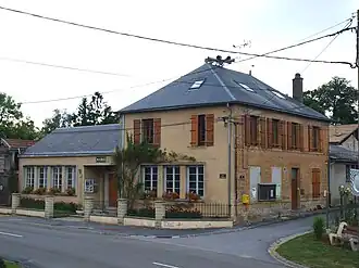 The town hall in Montcheutin | |
Location of Montcheutin | |
 Montcheutin  Montcheutin | |
| Coordinates: 49°17′31″N 4°49′17″E / 49.2919°N 4.8214°E | |
| Country | France |
| Region | Grand Est |
| Department | Ardennes |
| Arrondissement | Vouziers |
| Canton | Attigny |
| Intercommunality | Argonne Ardennaise |
| Government | |
| • Mayor (2020–2026) | René Francart[1] |
Area 1 | 9.64 km2 (3.72 sq mi) |
| Population (2022)[2] | 111 |
| • Density | 12/km2 (30/sq mi) |
| Time zone | UTC+01:00 (CET) |
| • Summer (DST) | UTC+02:00 (CEST) |
| INSEE/Postal code | 08296 /08250 |
| Elevation | 106 m (348 ft) |
| 1 French Land Register data, which excludes lakes, ponds, glaciers > 1 km2 (0.386 sq mi or 247 acres) and river estuaries. | |
Montcheutin (French pronunciation: [mɔ̃ʃøtɛ̃]) is a commune in the Ardennes department in northern France.
Population
| Year | Pop. | ±% |
|---|---|---|
| 1962 | 136 | — |
| 1968 | 166 | +22.1% |
| 1975 | 159 | −4.2% |
| 1982 | 136 | −14.5% |
| 1990 | 113 | −16.9% |
| 1999 | 118 | +4.4% |
| 2008 | 143 | +21.2% |
See also
References
- ^ "Répertoire national des élus: les maires". data.gouv.fr, Plateforme ouverte des données publiques françaises (in French). 2 December 2020.
- ^ "Populations de référence 2022" (in French). The National Institute of Statistics and Economic Studies. 19 December 2024.
Wikimedia Commons has media related to Montcheutin.