Boiry-Becquerelle
Boiry-Becquerelle | |
|---|---|
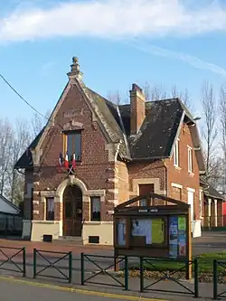 The town hall of Boiry-Becquerelle | |
 Coat of arms | |
Location of Boiry-Becquerelle | |
 Boiry-Becquerelle  Boiry-Becquerelle | |
| Coordinates: 50°12′51″N 2°48′57″E / 50.2142°N 2.8158°E | |
| Country | France |
| Region | Hauts-de-France |
| Department | Pas-de-Calais |
| Arrondissement | Arras |
| Canton | Arras-3 |
| Intercommunality | CU Arras |
| Government | |
| • Mayor (2020–2026) | Michel Dollet[1] |
Area 1 | 4.54 km2 (1.75 sq mi) |
| Population (2022)[2] | 473 |
| • Density | 100/km2 (270/sq mi) |
| Time zone | UTC+01:00 (CET) |
| • Summer (DST) | UTC+02:00 (CEST) |
| INSEE/Postal code | 62144 /62128 |
| Elevation | 66–98 m (217–322 ft) (avg. 78 m or 256 ft) |
| 1 French Land Register data, which excludes lakes, ponds, glaciers > 1 km2 (0.386 sq mi or 247 acres) and river estuaries. | |
Boiry-Becquerelle (French pronunciation: [bwaʁi bɛkʁɛl]) is a commune in the Pas-de-Calais department in the Hauts-de-France region in northern France.[3]
Geography
A farming village located 7 miles (11 km) south of Arras on the N17 junction with the D35 road.
Population
| Year | Pop. | ±% p.a. |
|---|---|---|
| 1968 | 198 | — |
| 1975 | 213 | +1.05% |
| 1982 | 288 | +4.40% |
| 1990 | 381 | +3.56% |
| 1999 | 419 | +1.06% |
| 2009 | 406 | −0.31% |
| 2014 | 409 | +0.15% |
| 2020 | 469 | +2.31% |
| Source: INSEE[4] | ||
Sights
- The church of St. Gervais, rebuilt after the destruction of the village during World War I.
See also
References
- ^ "Répertoire national des élus: les maires". data.gouv.fr, Plateforme ouverte des données publiques françaises (in French). 2 December 2020.
- ^ "Populations de référence 2022" (in French). The National Institute of Statistics and Economic Studies. 19 December 2024.
- ^ INSEE commune file
- ^ Population en historique depuis 1968, INSEE
Wikimedia Commons has media related to Boiry-Becquerelle.