Torcy, Pas-de-Calais
Torcy | |
|---|---|
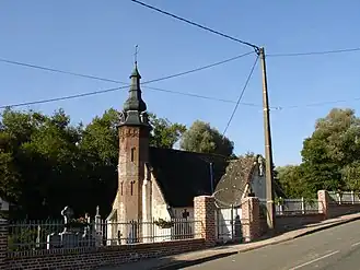 The church of Torcy | |
 Coat of arms | |
Location of Torcy | |
 Torcy  Torcy | |
| Coordinates: 50°29′04″N 2°01′24″E / 50.4844°N 2.0233°E | |
| Country | France |
| Region | Hauts-de-France |
| Department | Pas-de-Calais |
| Arrondissement | Montreuil |
| Canton | Fruges |
| Intercommunality | CC Haut Pays du Montreuillois |
| Government | |
| • Mayor (2020–2026) | Patrick Cornu[1] |
Area 1 | 5.27 km2 (2.03 sq mi) |
| Population (2022)[2] | 172 |
| • Density | 33/km2 (85/sq mi) |
| Time zone | UTC+01:00 (CET) |
| • Summer (DST) | UTC+02:00 (CEST) |
| INSEE/Postal code | 62823 /62310 |
| Elevation | 70–171 m (230–561 ft) (avg. 80 m or 260 ft) |
| 1 French Land Register data, which excludes lakes, ponds, glaciers > 1 km2 (0.386 sq mi or 247 acres) and river estuaries. | |
Torcy (French pronunciation: [tɔʁsi] ⓘ) is a commune in the Pas-de-Calais department of northern France.[3]
Geography
Torcy is located 11 miles (17 km) east of Montreuil on the D130 and in the valley of the river Créquoise. The nearest villages are Sains-lès-Fressin and Créquy.
Population
| Year | Pop. | ±% p.a. |
|---|---|---|
| 1968 | 166 | — |
| 1975 | 164 | −0.17% |
| 1982 | 144 | −1.84% |
| 1990 | 166 | +1.79% |
| 1999 | 142 | −1.72% |
| 2007 | 164 | +1.82% |
| 2012 | 160 | −0.49% |
| 2017 | 165 | +0.62% |
| Source: INSEE[4] | ||
Places of interest
- The church of St. Eloi, dating from the sixteenth century
- Baladin, a restaurant, bar and guesthouse
See also
References
- ^ "Répertoire national des élus: les maires". data.gouv.fr, Plateforme ouverte des données publiques françaises (in French). 2 December 2020.
- ^ "Populations de référence 2022" (in French). The National Institute of Statistics and Economic Studies. 19 December 2024.
- ^ INSEE commune file
- ^ Population en historique depuis 1968, INSEE
Wikimedia Commons has media related to Torcy (Pas-de-Calais).