Ligny-sur-Canche
Ligny-sur-Canche | |
|---|---|
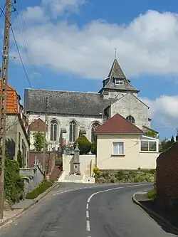 The church of Ligny-sur-Canche | |
 Coat of arms | |
Location of Ligny-sur-Canche | |
 Ligny-sur-Canche  Ligny-sur-Canche | |
| Coordinates: 50°17′06″N 2°15′32″E / 50.285°N 2.2589°E / 50.285; 2.2589 | |
| Country | France |
| Region | Hauts-de-France |
| Department | Pas-de-Calais |
| Arrondissement | Arras |
| Canton | Saint-Pol-sur-Ternoise |
| Intercommunality | Ternois |
| Government | |
| • Mayor (2020–2026) | Jean-Marie Delmotte[1] |
Area 1 | 7.17 km2 (2.77 sq mi) |
| Population (2022)[2] | 188 |
| • Density | 26/km2 (68/sq mi) |
| Time zone | UTC+01:00 (CET) |
| • Summer (DST) | UTC+02:00 (CEST) |
| INSEE/Postal code | 62513 /62270 |
| Elevation | 57–138 m (187–453 ft) (avg. 100 m or 330 ft) |
| 1 French Land Register data, which excludes lakes, ponds, glaciers > 1 km2 (0.386 sq mi or 247 acres) and river estuaries. | |
Ligny-sur-Canche (French pronunciation: [liɲi syʁ kɑ̃ʃ], literally Ligny on Canche) is a commune in the Pas-de-Calais department in the Hauts-de-France region of France[3] 25 miles (40 km) west of Arras, in the valley of the river Canche.
Population
| Year | Pop. | ±% p.a. |
|---|---|---|
| 1968 | 229 | — |
| 1975 | 219 | −0.64% |
| 1982 | 187 | −2.23% |
| 1990 | 197 | +0.65% |
| 1999 | 205 | +0.44% |
| 2007 | 199 | −0.37% |
| 2012 | 187 | −1.24% |
| 2017 | 194 | +0.74% |
| Source: INSEE[4] | ||
See also
References
- ^ "Répertoire national des élus: les maires". data.gouv.fr, Plateforme ouverte des données publiques françaises (in French). 2 December 2020.
- ^ "Populations de référence 2022" (in French). The National Institute of Statistics and Economic Studies. 19 December 2024.
- ^ INSEE commune file
- ^ Population en historique depuis 1968, INSEE
External links
Wikimedia Commons has media related to Ligny-sur-Canche.
This article is issued from Wikipedia. The text is available under Creative Commons Attribution-Share Alike 4.0 unless otherwise noted. Additional terms may apply for the media files.