Blaziert
Blaziert | |
|---|---|
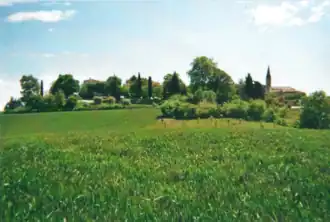 A general view of Blaziert | |
Location of Blaziert | |
 Blaziert  Blaziert | |
| Coordinates: 43°56′06″N 0°28′39″E / 43.935°N 0.4775°E | |
| Country | France |
| Region | Occitania |
| Department | Gers |
| Arrondissement | Condom |
| Canton | Baïse-Armagnac |
| Intercommunality | Ténarèze |
| Government | |
| • Mayor (2020–2026) | Guy Noël Dufour[1] |
Area 1 | 10.97 km2 (4.24 sq mi) |
| Population (2022)[2] | 128 |
| • Density | 12/km2 (30/sq mi) |
| Time zone | UTC+01:00 (CET) |
| • Summer (DST) | UTC+02:00 (CEST) |
| INSEE/Postal code | 32057 /32100 |
| Elevation | 111–222 m (364–728 ft) (avg. 134 m or 440 ft) |
| 1 French Land Register data, which excludes lakes, ponds, glaciers > 1 km2 (0.386 sq mi or 247 acres) and river estuaries. | |
Blaziert (French pronunciation: [blazjɛʁ]; Occitan: Blasièrt) is a commune in Gers, a department in southwestern France.
Geography

Population
| Year | Pop. | ±% |
|---|---|---|
| 1962 | 245 | — |
| 1968 | 200 | −18.4% |
| 1975 | 147 | −26.5% |
| 1982 | 138 | −6.1% |
| 1990 | 121 | −12.3% |
| 1999 | 124 | +2.5% |
| 2008 | 138 | +11.3% |
See also
References
- ^ "Répertoire national des élus: les maires". data.gouv.fr, Plateforme ouverte des données publiques françaises (in French). 9 August 2021.
- ^ "Populations de référence 2022" (in French). The National Institute of Statistics and Economic Studies. 19 December 2024.
Wikimedia Commons has media related to Blaziert.