Garravet
Garravet | |
|---|---|
Location of Garravet | |
 Garravet  Garravet | |
| Coordinates: 43°24′53″N 0°54′51″E / 43.4147°N 0.9142°E | |
| Country | France |
| Region | Occitania |
| Department | Gers |
| Arrondissement | Auch |
| Canton | Val de Save |
| Government | |
| • Mayor (2020–2026) | Daniel Worzniack[1] |
Area 1 | 9.09 km2 (3.51 sq mi) |
| Population (2022)[2] | 148 |
| • Density | 16/km2 (42/sq mi) |
| Time zone | UTC+01:00 (CET) |
| • Summer (DST) | UTC+02:00 (CEST) |
| INSEE/Postal code | 32138 /32220 |
| Elevation | 183–310 m (600–1,017 ft) (avg. 304 m or 997 ft) |
| 1 French Land Register data, which excludes lakes, ponds, glaciers > 1 km2 (0.386 sq mi or 247 acres) and river estuaries. | |
Garravet (French pronunciation: [ɡaʁavɛ]) is a commune in the Gers department in southwestern France.
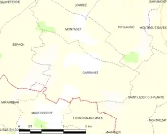
Geography
Population
| Year | Pop. | ±% |
|---|---|---|
| 1962 | 233 | — |
| 1968 | 217 | −6.9% |
| 1975 | 191 | −12.0% |
| 1982 | 155 | −18.8% |
| 1990 | 138 | −11.0% |
| 1999 | 121 | −12.3% |
| 2008 | 140 | +15.7% |
See also
References
- ^ "Répertoire national des élus: les maires". data.gouv.fr, Plateforme ouverte des données publiques françaises (in French). 2 December 2020.
- ^ "Populations de référence 2022" (in French). The National Institute of Statistics and Economic Studies. 19 December 2024.
Wikimedia Commons has media related to Garravet.